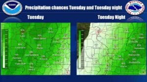
It will be a very different weather pattern in store for the region this week, as we shift from a dry pattern, to a rainy one.
Areas to our west are already getting some rain along a cold front, and Forecaster Rachel Trevino with the National Weather Service in Paducah says as it makes its way into our region Tuesday and Tuesday night, it’ll bring with it beneficial rain and slightly cooler temperatures.
The chances for rain will linger throughout the week and into the weekend, with our highest chances of rain currently falling on Saturday.
Then in the 8-to-14 day-outlook, it’s looking like more of the same, with above average chances for precipitation and above average temperatures in store.
We are currently in our fall severe weather season, and with cold and warm fronts fighting for control of the atmosphere, now is a good time to review any severe weather plans and update the batteries in your weather radios.
Stay tuned to the WHOP Family of Stations for any updates on our weather forecast.


