

Snow lovers are eagerly watching the forecast, as western Kentucky could see its first significant snowfall of the winter this coming weekend.
This winter event is still several days out, so Meteorologist Andy Lesage with the National Weather Service in Paducah says plenty can change between now and then, but they are feeling increasingly confident that someone is going to get something. Right now, the most likely area looks to be western Kentucky along the Tennessee border, but Lesage says it will come down to where the main body of this system tracks.
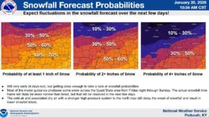
Right now, the timing looks to be from Friday night through the morning hours of Sunday, and some models are calling from anywhere between one inch of snow to over four inches of snow possible. Those details will get more ironed out in the coming days, with Lesage saying it’s looking like this will be a mostly snow event, with not much in the way of ice.
Thanks to the frigidly cold temperatures, which will only continue after the event, Lesage says any snow that does fall will be light and fluffy.
What could dash our snow hopes is a strong high-pressure system to our north—if it drops farther south than expected, it would delay the start of any snow and lower potential totals.
You know what that means—stay tuned to the National Weather Service in Paducah and the WHOP Family of Stations as more information becomes available about this approaching winter weather system.
