

The folks of not just western Kentucky, but the Southeast region as a whole, are winter weather weary, but it’s looking like we may finally have a warm up.
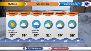
The upper 30’s wouldn’t sound like a warm up at any other time of the year, but after enduring temperatures in the single-digits and wind chills that bring things even colder, 38 on Monday is going to feel downright warm. And then it looks to stay in the 30’s for the rest of the week, which should seriously help with melting the snow and ice that remains from Winter Storm Fern.
There is a chance for some wintry precipitation on Tuesday into Wednesday, but at least right now, it looks like the majority of the precipitation that will fall in our area will be rain. Residual surface temperatures will still be very cold, which could possibly lead to that rain freezing on contact, but right now impacts are trending light.
Stay tuned to the WHOP Family of Stations for any watches or warnings that may develop with this approaching wintry system.