

If you’ve been thinking it feels an awful lot like spring outside, you’d be right, as those spring-like temperatures are set to bring a chance for severe weather this week.
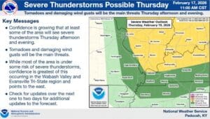
Our very mild temperatures will continue, with Lead Forecaster Keith Cooley with the National Weather Service in Paducah saying temperatures will linger in the upper 60’s and lower 70’s during the day, and then not cool off too much in the overnight hours. Those temperatures will stay pleasant until a cold front sweeps through Thursday night, bringing with it a chance of severe storms that could bring the risk for damaging winds and tornadoes.
There’s a lot of ‘shear’ in the atmosphere, which means that storms of a lot of wind behind them, which means damaging winds will be likely if storms develop.
Right now, Christian, Todd and Trigg Counties are in the marginal risk area, with a Slight Risk area issued for places to our north and east—though plenty could change between now and Thursday night.
On top of our severe weather risk, things will likely be blustery in the hours leading up to the event, and then there even could be some snow as the temperatures drop and the system leaves the area, though Cooley says that remains to be seen.
In the 8-to-14-day outlook, trends continue to show warmer than average temperatures in store, with above normal chances for precipitation. Cooley says there’s nothing in that time frame that’s ringing any warning bells at this time, but they’ll keep an eye on it.
Stay tuned to the WHOP Family of Stations for any watches or warnings that may arrive with our Thursday storm system.