

There’s a solid signal for rainfall to start off the work week, and that rainfall might just be worth the small chance for thunderstorms that comes with it.
Lead Forecaster Keith Cooley with the National Weather Service in Paducah says there’s a Slight Chance of severe weather in place for the bulk of the region Tuesday, though rain could move into the area as soon as Monday night. Cooley says they’re not expecting that high of a severe weather threat, but some strong winds and hail will certainly be possible.
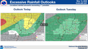
He says there’s a decent chance for some rain, with anywhere between one to two inches possible, depending on your location.
That rain is badly needed, especially in the southern Pennyrile region, which is in the grasp of Extreme Drought, as highlighted by U.S. Drought Monitor. In fact, Cooley says our region is currently running roughly nine inches below normal on rainfall, so any rain will help.
In the 8-to-14 day outlook, it looks like our early summer is here to stay, with above average temperatures in store with slightly above average chances of precipitation. Stay tuned to the WHOP Family of Stations for any watches or warnings that may develop with our early week storm systems.