

You really couldn’t ask for better June weather to start the work week off, but then storms and rain will slide back into our area Wednesday night, bringing potentially heavy rain with it.
Forecaster Rachel Trevino with the National Weather Service in Paducah says they’re not expecting much in the way of severe weather in our area Wednesday or Thursday—the bulk of the severe threat appears to be staying to our north and west—but they can’t completely rule out a stray severe thunderstorm.
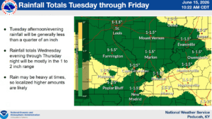
What’s looking more certain is the rainfall, with some places capable of seeing around two inches of rain by Friday, which will help further reduce our drought conditions.
Trevino says there is a Slight Risk of Excessive Rainfall highlighting the western Kentucky area on Thursday, and while they’re not expecting widespread flooding, standing water could certainly crop up in the usual low-lying and poor drainage areas.
In the 8-to-14-day outlook, rain looks to stay in our forecast, with above average chances of precipitation trending in the data and below average temperatures possible as well.
Stay tuned to the WHOP Family of Stations for any watches or warnings that may develop with our incoming stormy pattern.