

It’s a much better looking forecast this week compared to last week for western Kentucky, though we will have one more risk of wintry precipitation to get through before things start warming up.
Starting late Monday night and into Tuesday, Lead Forecaster Keith Cooley with the National Weather Service in Paducah says a winter weather system will clip through our region and bring with it a chance for precipitation. Our area looks to stay just a shade too warm for freezing rain or drizzle to actually fall here, but Cooley says they are worried about the possibility of ‘non-traditional freezing rain’, which is when the rain hits the very cold ground and freezes.
He says if that did happen, then a light frozen glaze is certainly possible, which could cause mischief on already icy surfaces and area roadways.
Cooley says the bulk of the system would move into the area early Tuesday morning, and their confidence for any accumulation at all remains very low.
Once we make it through this system however, things are looking up—temperature wise that is. Cooley says it’s not every day you’re excited to see temperatures in the 40’s, but they’ll maybe even get into the 50’s by the weekend, and that’s very welcome news.
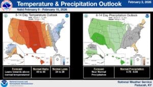
And the warm up might just continue, as the 8-to-14 day outlook shows trends for above average temperatures and near normal chances for precipitation. Cooley says things will still be cold at night, thanks for our lingering snow pack across the region, but they’ll take milder temperatures for sure.
Stay tuned to the WHOP Family of Stations for any watches or advisories that may spring up in the coming days.