

Our string of unseasonably warm temperatures will come to an abrupt end Sunday night and into Monday morning, as a cold front bullies its way across the region, bringing some storms with it.
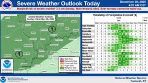
The National Weather Service in Paducah has highlighted the bulk of the region in a Marginal Risk for severe weather, including portions of Christian and Trigg counties Sunday night. The timing of this weather event is between 3 p.m. to 9 p.m. with the biggest threat to be damaging wind gusts.
Some gusts could reach 40 miles per hour, especially just behind the cold front that will crash into the region—and a brief spin-up tornado can’t totally be ruled out.
This front will bring much, much colder temperatures than we’ve had to the area, plunging us down into the teens and 20’s for the start of the new year. In fact, wind chills could put us into the single-digits on Monday morning, which does bring the potential for a ‘flash freeze’ where water pools on the roadway.
Stay weather aware and stay tuned to the WHOP Family of Stations for any watches or warnings that may develop for this cold front.