

The risk of severe weather Sunday could spoil some Memorial Day Weekend plans, with the National Weather Service in Paducah urging people to stay weather aware.
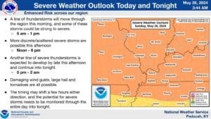
The entire region is under an Enhanced Risk of severe weather for most of the day Sunday, with Lead Forecaster Keith Cooley saying people could see multiple rounds of severe weather, starting in the morning hours, with all hazards possible.
Then, there could be scattered, pop-up supercell thunderstorms in the mid-day, before another round of storms moves through the region in the late afternoon and into the overnight hours.
Damaging winds, large hail and isolated tornadoes are all possible—with some of those tornadoes having the potential to be strong and longer-tracked. Cooley says the good news is, Monday is looking a lot better weather wise, with only a chance of scattered storms and rain showers.
Stay tuned to the WHOP Family of Stations and the National Weather Service in Paducah for any watches or warnings that develop with this severe weather system.