

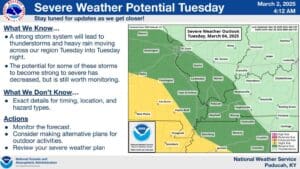
For a minute there it looked like March might come in like a lion to the region, but for now it’s looking like that threat for severe weather will stay to our south.
That’s according to Meteorologist Dan Spaeth with the National Weather Service in Paducah who says that while the worst of the severe weather will stay out of the area, we can still expect rain Tuesday and the winds could be downright blustery.
He says a wind advisory is not out of the question and from about noon Tuesday into the overnight hours folks could see some rain, with a thunderstorm possible.
And it may be too early to say, but Spring is certainly making a push in the coming weeks, with Spaeth saying the data is showing that things are trending above average temperature wise.
In the long-range outlook, it’s looking like March will be warm and rainy, with frequent chances for precipitation—but Spaeth says they’re not seeing much in the way of winter.
While the severe weather seems to have stayed out of our area this time, it won’t stay that way forever, and the first week of March is Spring Severe Weather Awareness Week for Kentucky, so now is a good time to make a severe weather plan for any future needs.