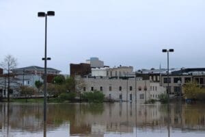
Hopkinsville Streets closed:
W. 9th St. at Bethel St.
Riverfront Dr. at W. 5th St.
E. 7th St. between S. Clay St. and S. Campbell St.
Donna Dr. between Karen Dr. and Mark Dr.
Dawn Dr.
Oakhurst and Hurst Drives
W. Riverwood Dr.
S. Riverwood Dr.
Woodmill Rd.
E. 21st St. at Woodmill Rd.
Pardue Ln. (High Water)
N. Sunset Circle (High Water)
Pyle Lane at Foxfield Rd. (High Water)
Canton Pike from Country Club to Pyle Lane (Power Lines Down)
Avoid these areas, drive with caution, and stay safe. Report emergencies to local authorities. We’ll provide updates as conditions improve.
Trigg County:
Glenwood Mill Road
Bush Road
Kings Chapel Road
East Lake Road
Dunkerson Bottom
Sumner King Road
Donnie Lane
Skinner Road
Old Dover Road
Donaldson Creek Road
Oak Grove Church Road
Pleasant Hill Road
High water signs have been placed at the following locations in KYTC District 2:
***This list only includes routes that are maintained by the state, and not city and county roadways.
Caldwell County
I-69 SB restricted to one lane at Exit 79
KY 91 at 8.5 mile point
KY 91 17.2-18 mile points
KY 91 at 11.6 mm at KY 2080 (Cadiz Street)
KY 126 at the 1 mile point
KY 128 at 0.4 mile point
KY 139 at the 4.5 mile point
KY 139 between the 14.4-14.7 mile points
Christian County
I-169 between the 5-11 mile points
U.S. 41 between the 11-11.4 mile points
U.S. 41 between the 12.1-12.3 mile points
US 41 between the 14-14.2 mile points
US 41 between the 24-24.5 mile points
U.S. 41A between 15.2-15.9 mile points
KY 107 between the 18.1-18.6 mile points
KY 109 between the 10.9-11.1 mile points
KY 117 between the 15.8-18.9 mile points
KY 164 between the 9.4-9.6 mile points near Newstead Road
KY 272 between the 6.8-6.9 mile points near Square Deal Grocery
KY 272 between the 7.3-8.2 mile points
KY 345 between the 9.2-10.6 mile points
KY 380 between the 2.6-2.8 mile points
KY 400 between the 0-1.3 mile points
KY 695 between 0-10 mile points
KY 1338 between the 3-4.4 mile points
Daviess County
KY 142 between 4.4-5.9 mile points (NEW)
KY 298 between the 2-3 mile points
KY 661 between the Hancock County line and the 1.9 mile point
KY 762 between the 6.8-8.3 mile points
Hancock County
KY 661 near the Daviess County line
KY 1403 between 0-1 mile points
KY 2181 between the 4-4.4 mile points near Blackford Bottoms
Henderson County
KY 136 between the 0-10 mile points
KY 268 between the 1-8 mile points
KY 1557 between the 2-3 mile points
Hopkins County
U.S. 41A between the 12-13 mile points – Providences Levee
U.S. 62 between the 16-17 mile points between Nortonville and White Plains
KY 70 between the 11-13 mile points near Richland Church
KY 109 between 6-8 mile points near Ferguson Town Road
KY 112 at the 5.4 mile points
KY 138 between the 0-1 mile points at Slaughters
KY 281 (Island Ford Road) between 0-2 mile points
KY 502 between the 1-5 mile points
KY 502 between the 7-8 mile points
KY 813 between the 10-11 mile points near Mortons Gap
KY 1033 between 0-2 mile points near Vandetta
KY 1069 (Stagecoach Road) between the 0-2 mile points
KY 1302 (Pleasant View Road) between the 1-2 mile points
KY 1337 between the 4-5 mile points
KY 2083 between the 0-1 mile points near Little Valley
KU 2281 (Carriage Lane) between the 0-1 mile points
KY 2337 (Tucker Schoolhouse Road) at the 4 mile point
KY 3059 (Wells Road) between the 1-2 mile points
Muhlenberg County
U.S. 431 between the 10.7-11 mile points
KY 179 between the 4-5 mile points
KY 181 between the 12.5-12.7 mile points
KY 181 between the 17.5-18.3 mile points
KY 277 between 0.9-1.2 mile points
KY 1163 between the 2-4 mile points
KY1379 between the 0-6.1 mile points
KY 1380 between the 2.2-3.7 mile points
KY 2270 between the 6.2-6.4 mile points
KY 2270 between the 6.9-7.1 mile points
KY 2533 between the 0-0.7 mile points
KY 2590 between the 0-0.4 mile points
KY 2590 between the 2.2-2.8 mile points
Ohio County
U.S. 62 between the 4.6-5.5 mile points (NEW)
U.S. 62 between the 8-10 mile points
U.S. 62 between the 15-17 mile points
KY 54 between the 2-3 mile points
KY 69 between the 12-13 mile points
KY 69 between the 13.7-14.1 mile points (NEW)
KY 69 between the 15.6-16.1 mile points (NEW)
KY 69 between the 18-19 mile points
KY 136 between the 3-4 mile points
KY 273 between the 3-3.4 mile points
KY 505 between the 14.2-15.6 mile points
KY 764 between the 6-7 mile points
KY 919 between the 3-4 mile points
KY 1245 between the 3.8-4.7 mile points (NEW)
KY 1543 between the 3-4 mile points
KY 2670 between the 2-2.5 mile points
Union County
KY 1452 full length
KY 1637 full length
Webster County
KY 120 between the 10-11 mile points
KY 132 between the 12-13 mile points
KY 138 between the 10.3-10.8 mile points at Slaughters
KY 270 between the 6.8-8.3 mile points
KY 874 between the 1.6-2 mile points
KY 2836 between 0-1 mile points
If you see high water, don’t take a chance. Turn around, don’t drown.


