

The name of the game this week, at least in the weather, is rain and hot temperatures before it dries out in the weekend—giving us a real taste of summer.
Forecaster Rachel Trevino with the National Weather Service in Paducah says rain chances will persist through the bulk of the week, though the best chances will be Monday into Tuesday morning. In fact, there is a Flood Watch in effect for the bulk of the area, including Christian, Todd and Trigg counties, until 8 a.m. Tuesday morning.
And several of those areas have already picked up a couple inches of rain, and with a Marginal Risk of strong to severe storms in effect, it’s likely we’ll pick up a few more inches before all is said and done.
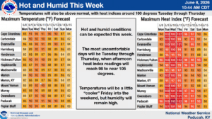
Trevino says that, normally, cloudy skies and rain help keep temperatures down, but that doesn’t seem to be the case this week. Temperatures will climb into some real heat, with heat index values of 100 degrees possible Wednesday and Thursday.
Those hot temperatures will stick with us until the weekend, before it starts ‘cooling down’ some Friday and Saturday, but with the high humidity sticking around, it’s still going to feel in the 90’s.
In the 8-to-14-day outlook, it’s looking like our above average chances for rain will stick around, but trends in the data are suggesting we might see an actual cool down, with below average temperatures possible.
Trevino says many areas have seen marked improvement on their drought conditions, with only isolated areas of extreme drought remaining, but she feels somewhat confident that will improve even more with this ongoing rain event.
Stay tuned to the WHOP Family of Stations for any watches or warnings that may develop with our slow moving weather system.