

It’s going to feel an awful lot like fall to start this week out, with rain and cooler temperatures in store, but don’t get used to it, because it’s going to warm right back up afterwards.
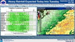
Our best chances of rain will be Monday night into Tuesday, with Forecaster Rachel Trevino with the National Weather Service in Paducah saying some place could get between two-to-three inches of rain—a welcome relief for our dry conditions.
The rain will bring cooler temperatures, down into the 70’s during the day and the 40’s at night, before it starts warming right back up for the weekend.
Drought conditions have already improved and this coming rain will help even more—but then Trevino says it’s set to dry out once again in the 8-to-14-day outlook.
Locally higher rainfall amounts will be possible this week, which could result in some flooding issues in the usual low-lying and poor drainage areas, so stay tuned to the WHOP Family of Stations for any watches or warnings that spring up.