

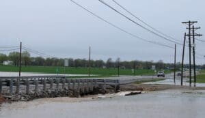
Flooding Street Closure Update – April 8, 2025 (0857) in Hopkinsville:
The following streets are CLOSED due to flooding:
• Cardinal Dr
• S Cavalcade Cir at Secretariat
High Water Areas – Proceed with Caution:
• Secretariat
Please do NOT drive around barricades. If water is over the road, turn around, don’t drown.
High water signs have been placed at the following locations in KYTC District 2:
***This list only includes routes that are maintained by the state, and not city and county roadways.
ALERT: I-69 blocked at I-169 in Hopkins County and I-24 in Lyon County due to flooding.
Todd County has no state roads closed at this time.
Caldwell County
U.S. 62 at the 18 mile point (CLEAR)
KY 70 between 14.9-15.7 mile points
KY 126 at the 4.7 mile point
KY 128 between the 3.3-3.4 mile points
KY 139 between the 3-4.5 mile point
KY 293 between the 18.1-20.4 mile points
KY 515 at the 2.2 mile point
KY 672 at 14.20 at KY 1627
KY 1272 between the 0-3.3 mile point
KY 1495 at the 2.9 mile point
KY 1592 between 1.5-2.6 mile points
KY 1627 between 7.4-8 mile points
KY 2066 between 0-0.9 mile points
Christian County
U.S. 41 between the 2.77-2.88 mile points
KY 107 between 1-2 mile points
KY 107 between 8.2-9 mile points
KY 115 between the 0-1 mile points
KY 117 between the 0-1.8 mile points (US 41A to Bell Station Rd)
KY 117 between the 15.8-18.9 mile points
KY 272 between the 3-6.8 mile points
KY 272 at the 9.6 mile point
KY 345 between the 4-7.3 mile points (KY 117 to KY 107)
KY 345 between the 9.2-10.6 mile points
KY 400 at 1.3 mile point
KY 695 between 3.8-4.4 mile points
KY 695 at the 8.6 mile point
KY 813 from 0-2 mile points at Hopkins County line
KY 1296 between the 1.5-2 mile points
KY 1338 between the 3-4.4 mile points
KY 1453 between 1.8-2.2 mile points
KY 1914 at the 2.3 mile point
KY 3186 at the 0-0.8 mile points
Hopkins County
I-69 NB at Exit 117 ramp to U.S. 41
I-169 southbound Exit 30 ramp to U.S. 41 blocked by water at Mannington
U.S. 41A between the 12-13 mile points – Providences Levee
U.S. 62 between the 1-2 mile points in Dawson Springs between KY 109 and Casey’s (CLEAR)
U.S. 62 between the 2.2-2.4 mile points (CLEAR)
U.S. 62 between the 3-4 mile points near Lucas Circle (CLEAR)
U.S. 62 between the 20-21 mile points
KY 70 between the 0-2 mile points at the Caldwell County line
KY 70 between the 23-24 mile points
KY 85 between the 4-7 mile points towards McLean County
KY 109 from KY 291 to KY 814 (CLEAR)
KY 138 at KY 1033
KY 293 between the 0-3.16 mile points at Webster County line
KY 370 between the 0-1 mile points
KY 502 between the 1-5 mile points
KY 862 between the 2.8-5 mile points
KY 892 between the 5.506 mile points (NEW)
KY 1033 between 0-2 mile points near Vandetta
KY 1034 between 0-1.5 near Johnson Island Church
KY 1220 between the 3-4 mile points
KY 2280 between the 0-2.2 mile points
KY 3059 (Wells Road) between the 1-2 mile points
Muhlenberg County
U.S. 62 at the Hopkins County line
U.S. 431 at the 5 mile point
KY 70 at the Hopkins County line
KY 70 between the 22.5-23 mile points at the Muhlenberg-Butler line
KY 175 between the 22-24 mile points
KY 277 between 0.9-1.2 mile points
KY 949 at Butler County line
KY 1163 between the 2-4 mile points
KY1379 between the 0-6.1 mile points
KY2107 between the 0-1.9 mile points (NEW)
Logan County
- KY 3201 – Closed at mile marker 0 to 1.
- KY 1153 – Closed at mile marker 3 to 4.
- KY 107 – Closed at mile marker 5.
- KY 765 – Closed at mile point 2.9.
- KY 1040 – Closed at mile point 6.2.
- KY 722 – Closed at mile point 3.
- KY 2377 – Closed at mile point 0.2.
- KY 663 – Closed at mile point 6.
*** U.S. 431 in Muhlenburg County closed at Tunnel Hill due to significant roadway damage from an active embankment slide.
U.S. 431 will remain closed around mile point 5 near Union Ridge Road and Myer’s Chapel Road south of Belton until further notice as the slide is actively moving.
Trigg County
KY 1507/Barefield Road is CLOSED with high water at the 1 MP. This is between KY 958/Montgomery Church Road and KY 128/Wallonia Road.
KY 958/Barefield Road is CLOSED with high water from the 0-1 MP.
KY 126/Buffalo Cerulean Road is CLOSED with high water from the 0-1 MP (Horse Creek).
KY 124/Cerulean Road is CLOSED with high water from the 10-11 MP (Muddy Fork Little River) near the county line.
KY 139/South Road is CLOSED with high water between the 16-17 MP (Little River) in Cadiz.
KY 139/South Road is CLOSED with high water at the 13 MP, just south of KY 545/New Hope Road.
Interstate 69 (District 2)
Interstate 69 is BLOCKED by high water at around the 90-mile marker in Hopkins County (District 2), just west of Dawson Springs. Motorists will be detoured in Lyon County, taking Interstate 24 east and Interstate 169 north to rejoin I-69 in Hopkins County near Mortons Gap. The Interstate 24 Exit 42 northbound ramp to I-69 and the northbound ramp for I-69 Exit 71 at U.S. 62 are BLOCKED.
Lyon County
The Interstate 24 Exit 42 northbound ramp to I-69 is BLOCKED due to flooding on Interstate 69 at the 90-mile marker in Hopkins County (District 2), just west of Dawson Springs. Motorists will be detoured via I-24 east and I-169 north to rejoin I-69 in Hopkins County near Mortons Gap. Access to the northbound ramp for I-69 Exit 71 at U.S. 62 is also BLOCKED.
KY 295 S is CLOSED with high water near the 3.6 MP near the entrance of U.S. 62.
KY 819 is CLOSED with high water at the 2.3 MP (Panther Creek).
KY 1055 is CLOSED from approx. the 2-2.5 MP between Eddyville Springs Road and Perry Springs Road due to a slide caused by flash flooding.
Marshall County
KY 795/Scale Road is open at the 6 MP between KY 1396/George Clark Road and KY 782/Sawyer Creek Road. – CLEAR
KY 1462/Benton-Birmingham Road is CLOSED with high water between 0-1.3 MP. This is between KY 408/E. 12th Street and KY 1477/Benton Briensburg Road.
KY 1949/Wadesboro Road is CLOSED with high water at the 7.4 MP at the I-69 Tunnel.
KY 1311/Slickback Road is CLOSED with high water between the 3-5 MP.
KY 1949 is CLOSED at about the 2.3 MP where pavement has washed out due to flash flooding. This is near Zion Baptist Church and between KY 2606 and KY 1311.
KY 2595/Lakeview Church Road is CLOSED with high water from the 2.5 MM/Ruggie Cemetery Road to the 3.8 MM/Red River Road, near Kentucky Dam Village.