

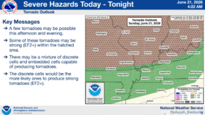
Western Kentucky and the surrounding region does have a risk of severe weather today, with most of the region highlighted in a Slight Risk for all hazards Sunday into Monday.
The National Weather Service in Paducah calls it a complicated forecast, with isolated severe storms possible during the afternoon, and its likely those storms would form a more organized line heading into the evening. Storms could linger into the overnight hours and into Monday morning.
The most likely time to see storms will be from noon Sunday into the early morning hours Monday, and any storms that develop will bring the risk for damaging winds, large hail and a couple of tornadoes.
While it’s likely Father’s Day won’t be a total wash out, stay tuned to the WHOP Family of Stations and the National Weather Service for any watches or warnings that may develop with our Sunday storm system.