

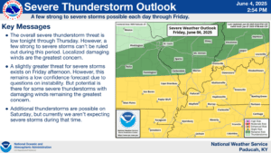
A risk for severe weather does exist throughout the end of the week and into the weekend, with the bulk of Kentucky under a Slight Risk at this time.
A cold front is stalling out over the region, bringing persistent rain and waves of potential thunderstorms to western Kentucky—including Christian, Todd, Trigg and surrounding counties—and a severe storm or two will be possible.
The main risks for any thunderstorms that manage to develop Thursday afternoon and especially on Friday, would be damaging winds and heavy rain, and while the tornado risk is low, an isolated tornado would be possible.
Widespread flash flooding issues are not anticipated, but where thunderstorms and rainstorms train in the same areas could result in standing water in the usual low-lying and poor drainage areas.
Stay tuned to the WHOP Family of Stations for any watches or warnings that may develop along this storm front.