

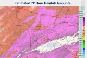
The National Weather Service in Paducah is reporting that a swath of western Kentucky, from Calloway County through Todd County, received possibly over a foot of rain from Wednesday to Sunday morning.
While that rain—and the storms that brought it here—have finally moved out of our area with the passage of a cold front, flooding will likely continue for several days as water makes its way from small creeks and streams into larger rivers, which will then carry it further downstream.
If you go out travelling, make sure to stay alerts for water over the roadway, especially at night when it can be harder to see and assess the depth of water.
Now, it’s looking we will finally see the sun starting on Monday, giving us a chance to dry out. The downside—all of western Kentucky is under a Freeze Watch starting at midnight Tuesday, as that cold front that caused so much trouble finally brings the cold.