

Despite schools coming back into session and summer breaks coming to a close, it’s still going feel very much like summer for the foreseeable future.
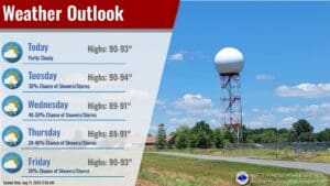
Lead Forecaster Keith Cooley with the National Weather Service in Paducah says it’s going to be pretty typical summer weather this week, with very scattered pop-up rain chances and hot temperatures that will only tick up heading towards the weekend.
That’s a familiar pattern to western Kentucky and surrounding areas, following a spring of above normal rainfall and now, if you can believe it, drought conditions are starting to show up across the region as things are finally starting to dry out.
Rain chances will be minimal this week, but not zero, with Cooley saying the best chances for rain fall will be Tuesday night into Wednesday night.
Other than that, a stray thunderstorm during the heat of the day can’t be ruled out, and any that did fall would likely be heavy rain makers, with some gusts of damaging winds possible.
In the 8-to-14-day outlook it’s looking like the area could see above average temperatures, along with above average chances for rain, so we’ll see if those drier conditions hold out.