

After what felt like a never-ending stretch of the threat of severe weather and record-breaking level of flooding, western Kentucky is in for a sunny, albeit chilly, stretch of weather.
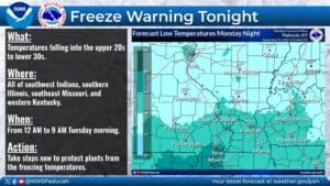
With that in mind, there is a Freeze Warning in effect starting at midnight for all of western Kentucky, with Meteorologist Justin Gibbs with the National Weather Service in Paducah saying that’s the biggest weather threat facing us this week—if you’re a plant.
There is a chance for some rain fall on Thursday, but it will be light, so hopefully flood waters will have a chance to recede in the coming days.
Gibbs says there’s no big signals in the long-range forecast for severe weather either, but flooding does continue on area roadways and rivers, so expect to see standing water for some time.
The National Weather Service is also reporting that six western Kentucky counties have new records for rainfall over a three-day period from April 3 to April 5, and that includes Christian County at 12.11 inches, breaking the record of 10.85 inches that fell in 1997. Trigg County measured 12.13 inches, breaking their record of 10.39 inches in 1989, while Muhlenberg County saw nearly 13 inches at 12.94 inches in that time frame. Of course, locally higher amounts did happen, with some folks reporting upwards of 14 inches during this rainfall event.