

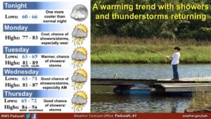
Hopefully you enjoyed the calm, beautiful weather this past weekend, because the temperatures are set to rise and with them comes the chance for storms.
Forecaster Keith Cooley with the National Weather Service in Paducah says the temperatures and the humidity will sneak up this week, back into more summer-like ranges.
There will be daily chances for heavy rain and some storms, with flash flooding certainly a possibility wherever storms linger in the same areas.
There is a chance for severe weather, possibly Thursday night into Friday, but Cooley says confidence is very low in that forecast at the moment—several models push the cold front that will move through the region out into the weekend, so timing is up in the air.
Right now, it’s looking like the main threats would be damaging winds and maybe a spin-up tornado, but it’s too far out to be sure. Cooley urges folks to remain weather aware as they head into the work week, as meteorologists work to iron out the details.
Then, in the 8-to-14 day outlook, things look to return to a drier pattern, with above average temperatures in store but below average chances of precipitation in the trends.