

The threat of severe weather remains for the entire region, including Christian, Todd and Trigg counties, Monday evening and into the overnight hours, as severe storms will work their way from west to east.
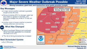
Todd County is currently highlighted under a Slight Risk for severe weather, while Christian, Trigg and counties to our west are in the Enhanced Risk. Those areas could still shift, so Warning Coordination Meteorologist Christine Wielgos with the National Weather Service in Paducah advises folks to not get too caught up in the colors on the map.
She says no matter where you are in the region, you’re under the gun for severe weather, and that includes damaging straight line winds, very large hail and tornadoes, some of which could be strong.
Wielgos says some of us are in for a for a long night, as the event will start as possible supercells in Missouri and Illinois and then race for western Kentucky, reaching out area as a squall line around midnight. She says they’re hopeful the storms will be waning some in intensity by that time, but she cautions to not let your guard down.
After that line of storms moves out in the early morning hours, western Kentucky has another chance for severe storms on Tuesday, with the area under a Slight Risk. They’re expected damaging winds and hail to be the main threats from those storms.
Then, in the 8-to-14 day outlook, Wielgos says the weather is looking pleasant and cool for the rest of the week and into the weekend.
The storms on Monday and Tuesday will hopefully bring some beneficial rain with them, with minor flooding issues possible on Tuesday in the usual low-lying and poor drainage areas—but it will also help bust the extreme drought that has settled into the region.
Stay tuned to the WHOP Family of Stations for any watches or warnings that could be issued as a part of our stormy start to the work week.